


The hike across Besseggen
Most visitors embark on the popular ferries Gjende in order to access the world famous Besseggen hike.
The Gjende ferries leave from the harbour next to Gjendesheim in the morning and take you directly to Memurubu. This is where the full day hike back to Gjendesheim scaling the Besseggen ridge starts.
It is also fully possible to do your hike the other way round: Start walking uphill directly from Gjendesheim or and Bessheim, scramble down the Besseggen ridge and end up at Memurubu, where you board the Gjende ferry and return back to Gjendesheim.
1. DOCK AT GJENDESHEIM
You can drive to Gjendesheim with your car, and Gjendesheim tourist lodge is placed by the docks. Most people take the ferry to Memurubu, and then start their hike from there over the famous Besseggen. You could also take the opposite direction, by starting your hike up Besseggen from Gjendesheim.
2. GJENDEFERRY
Find timetable for the ferry at https://www.gjende.no/en/
3. DOCK AT MEMURUBU
The path ascending up from Memurubu is steep, and with a nice view to the glacier river Muru. It is amongst others the river Muru that brings sandparticles to Gjende, that creates the distinctive emerald green color.
4. BJØRNBØLTJØNN
Fill up your drinking bottle with fresh clear mountain water.
5. BANDET
Bandet is a small ridge that keeps Bessvannet lake (1374 MASL) from pouring out into Gjende that is 400 metres lower. It is said that Bessvannet is Norways cleanest lake, with a clear sight on 30 metres in the water. Many take their lunchbreak here.
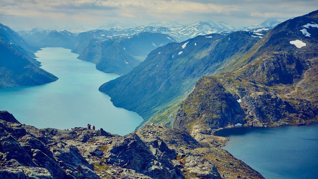
6. BESSEGGEN
The steep and narrow ridge that starts at Bandet is the Besseggen itself. Dont forget to enjoy the view on Gjende and Gjendealps. The most known place at Besseggen from photographies is just before you pass the last part of the ridge.
7. VESLEFJELL
Here is the cairn that marks the highest point of the hike at 1743 MASL. The path splits about 1km ahead, and takes you to either Gjendesheim or Bessheim.
USEFUL TIPS
EQUIPMENT
- Hiking boots
- Extra pair of socks
- Basic first-aid equipment
- Bandages for blisters
- Sunglasses
- Wool underwear
- Wind- and waterproof jacket and pants
- Mittens
- Wool cap
- Minimum 1 litre of water
- Map and compass/gps
- Lunch pack
- Some sweets to keep you cheery
- Camera for photographic evidence
- Money or bank card for the boat and souvenir (or for purchasing photographic evidence…)
APPROXIMATE DURATIONS
Most people use between 6 and 8 hours, including time for rest stops, when traversing the Besseggen route. With an elevation increase of nearly 1,000 metres (over 3,000 feet), Besseggen is a long hike. The fastest recorded time so far was achieved by Reidar Andreassen in 1963, when the Besseggløpet (Bessegg Run) was arranged for the 3rd time with the official record being 1 hour and 16 minutes. In 2011 the run was held once again and it will now be arranged annually along the classic route from Memurubu to Gjendesheim.
BOAT SCHEDULES
Look at www.gjende.no. Tag your pics at Instagram: #Besseggen, #utno, #gjendebu og #gjendesheim
ACROPHOBIA
What if you realise that you have acrophobia (fear of heights)? This has happened to many people in the past… One option is to turn back and perhaps have an extra overnight stay at Memurubu. Otherwise, you might find someone who can help you to focus on the trail and not on the elevation. There are no exposed stretches once you have passed the ridge!
THE MEANING OF BESSEGGEN
«Bess» is derived from the Norse term «bersi» meaning ‘bear’. Many of the local place names indicate that there were once a large number of bears here. Jo Gjende shot a bear near Bjørnbølet, which they had followed all the way far away from Heidal!
Gjende & Bessvatnet
Lake Gjende is approximately 20 km long with an average width of about 1 km. The mountain walls climb to nearly 1.300 metres above the lake surface at their highest point. With a maximum depth of 150 metres. Gjende is the deepest lake in 1otunheimen National Park.
The lake was carved by glacial ice.
The high resilient mountain masses to the north and south caused the huge ice masses to be pressed together into a smaller area and the considerable thickness caused the ice to dig so deeply.
The blue green colour occurs due to the washing of many fine glacial particles into Lake Gjende which reflect the daylight. The colour is further accentuated by the fact that Gjende is closely encircled by dark mountainsides and lush green vegetation.
Gjende is a good fishing lake and particularly the outflow at the Gjendeosen river mouth is a popular and sought after fishing spot for many anglers.
Lake Bessvatn is situated at an elevation of 1. 374 metres above sea level and stands in stark contrast to Lake Gjende due to its blue colour. From Bessheim it is about a 5 km walk up to the river mouth, and there is a nice trail all the way. The lake itself is 7 km long and 120 m deep. It has been designated as Norway’s cleanest lake and you can see the bottom even at a depth of 30 metres.

